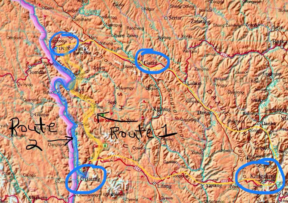
 Route options. Starting point of Route 1: the Chinese name is Moduoxiang, but I am hoping to learn the accurate and true name of this village, which is Tibetan. This village is on the main road from Lithang to Bathangand is 267 km to Derge. Route 2 follows the Yangtze and begins in Bathang, following the "new" border of forcefuly colonized Tibet. The beginning: 3D satellite image of roads and paths along proposed route #1. There is a main paved road that winds through the mountains and zig-zags up and down steep passes, unpaved roads that follow the course of the river and tend to be on the opposite banks of the villages, and the ridgetop paths that disappear into trees and grasslands. I've been spending hours of research online to determine what I'll need for this trek, along with learning about the topography and geographic area. It's so fun! All of this has led me to multiple websites and books about the history and culture of Tibet and Kham, which I find fascinating to the point of addiction! Yesterday, I spent 8 straight hours reading and searching online--not just for the trek, but for geographic and cultural data on Eastern Tibet, the area in which I will spend most of my time. With Google Maps, https://www.google.com/maps/dir/Moduoxiang,+Batang,+Garze,+Sichuan,+China,+627652/Baiyu,+Garze,+Sichuan,+China/@30.2659313,99.2150887,2292a,35y,357.66h,46.74t/data=!3m1!1e3!4m14!4m13!1m5!1m1!1s0x371c0ac07d5b0601:0x600249cb0e252d59!2m2!1d99.21119!2d30.18658!1m5!1m1!1s0x371b3617fef50557:0x4f91ad95c0e886bc!2m2!1d98.824182!2d31.209913!3e0 I get a bird's eye view of the terrain and actual paths I will be trodding! It's so awesome! This helps me determine which route to take, of which there are two so far that are of interest! The first route may take me through more rugged hinterlands, with sparsely laid villages. The alternate will be at slightly lower elevation of 3000-3500m, along the Yangtse River (according to Lobsang, my dependable and knowledgeable resource who writes https://www.thelandofsnows.com/ and heads up the Himalayan guide company, https://www.thelandofsnows.com/. In fact, Lobsang's wisdom and expertise in traveling Tibet and Kham, which he shares so generously on his websites, are what enabled me to travel through Kham last summer, and what led me to decide on a solo trek in Eastern Tibet in July! I trust the information he offers, quite literally, with my life! Much gratitude to you, Tibet Trekking Guru and mountain friend!) The topo map allows me to fly over the mountain ridges and river valleys where can determine if my paths shall follow paved main roads, unpaved side roads, or top-of-ridge-maybe-it's-a-road-and-maybe-it's-not-a-road roads! I can locate water sources along the way as well, although I plan to stay near river tributaries on Route 1, and Route 2 parallels the Yangtze the entire trek. The main concern I have is not having a reliable map (yet) or Tibetan village names. I won't have wifi access on the trek, and of course, Big Red Brother renamed everything when it "peacefully liberated" (that's just a LIE!) the Tibetan people from their already peaceful and free lives, and illegally and immorally redrew borders, which I refuse to honor due to their forced occupation and colonization of the area. That is another topic I will address another time! I will need the local Khampa names of these towns and villages, so that if I take the wrong pass, I will be able to figure out where I am (yes, of course I will have a compass!) It won't be that terribly difficult to find a village or locate nomads if I get lost; I will be pretty much heading due north. If I veer off course, I'll either end up further in Western Tibet - Chamdo-- or in Kandze. I can hike along the ridgelines when I want more adventure, higher elevations and a view. I can overnight in the valleys next to the river if the winds are high or if I need additional water. I still have to check out https://www.freemaptools.com/elevation-finder.htm to determine elevations of the peaks and river valleys along the two routes. What's most important; however, is that I stay safe and warm and "hike my own hike": go at my own pace, stay hydrated, keep warm at night, prevent injury, and avoid dogs. I don't need to worry about wild animals or crazy, violent people, which is a relief. Currently, my main concerns are getting all my gear in time, breaking in my boots, and increasing my physical conditioning to be able to hike 5-15 miles in rugged, backcountry mountain terrain, every day for 2-3 weeks! I can't wait!!! Click read more to the right! Elevations of nearby towns: Lithang 3956 Bathang 2575 Pelyul (Ch: Baiyu) 3006 Derge (Ch Dege) 3290 Kandze (Ch Ganzi) 3400 Some remarkable books I discovered in my research! So many books of historical importance that are hard to find that tell the true story of the so-called "peaceful liberation" of Tibet, the forced colonization of Tibet by China; the people of which still wish for freedom! These give me more background on the people and the area, as well as historically accurate place names. The first two recount the rebellion of the Khampa Tibetans against Chinese occupation during the Cultural Revolution, including documents citing Mao and the Dalai Lama. The last two refer to other areas, but are fodder for my trek in Nepal next year and a future trip to Amdo, Tibetan areas north of Chengdu.
0 Comments
Leave a Reply. |
Gallivanting Goddess...Fears nothing! Archives
September 2019
Categories
All
|
 RSS Feed
